Friday, March 11, 2011

New 7 Wonders of the World

In 2001 an initiative was started by the Swiss corporation New 7 Wonders Foundation to choose the New Seven Wonders of the World from a selection of 200 existing monuments. Twenty-one finalists were announced January 1, 2006. Egyptians were not happy that the only original surviving original wonder, the Great Pyramid of Giza, would have to compete with the likes of the Statue of Liberty, the Sydney Opera House, and other landmarks, calling the project absurd. In response, Giza was named an honorary Candidate. The results were announced on July 7, 2007:

Wonder       Date of construction         Location
Great Wall of China  5th century BCE – 16th century CE         China
Petra  c.100 BCE           Jordan
Christ the Redeemer  Opened 12 October 1931         Brazil
Machu Picchu  c.1450 CE         Peru
Chichen Itza  c.600 CE         Mexico
Colosseum  Completed 80 CE            Italy
Taj Mahal  Completed c.1648 CE         India
Great Pyramid of Giza (Honorary Candidate)  Completed c.2560 BCE         Egypt


1. Great Wall - China
 
 Great Wall of China

The Great Wall of China is a series of stone and earthen fortifications in northern China, built originally to protect the northern borders of the Chinese Empire against intrusions by various nomadic groups. Several walls have been built since the 5th century BC that are referred to collectively as the Great Wall, which has been rebuilt and maintained from the 5th century BC through the 16th century. One of the most famous is the wall built between 220–206 BC by the first Emperor of China, Qin Shi Huang. Little of that wall remains; the majority of the existing wall was built during the Ming Dynasty.

Great Wall of China

The Great Wall stretches from Shanhaiguan in the east, to Lop Nur in the west, along an arc that roughly delineates the southern edge of Inner Mongolia. The most comprehensive archaeological survey, using advanced technologies, has concluded that the entire Great Wall, with all of its branches, stretches for 8,851.8 km (5,500.3 mi). This is made up of 6,259.6 km (3,889.5 mi) sections of actual wall, 359.7 km (223.5 mi) of trenches and 2,232.5 km (1,387.2 mi) of natural defensive barriers such as hills and rivers.

The Great Wall at Mutianyu, near Beijing

Before the use of bricks, the Great Wall was mainly built from rammed earth, stones, and wood. During the Ming Dynasty, however, bricks were heavily used in many areas of the wall, as were materials such as tiles, lime, and stone. The size and weight of the bricks made them easier to work with than earth and stone, so construction quickened. Additionally, bricks could bear more weight and endure better than rammed earth. Stone can hold under its own weight better than brick, but is more difficult to use. Consequently, stones cut in rectangular shapes were used for the foundation, inner and outer brims, and gateways of the wall. Battlements line the uppermost portion of the vast majority of the wall, with defensive gaps a little over 30 cm (12 in) tall, and about 23 cm (9.1 in) wide.

The Great Wall

While some portions north of Beijing and near tourist centers have been preserved and even extensively renovated, in many locations the Wall is in disrepair. Those parts might serve as a village playground or a source of stones to rebuild houses and roads. Sections of the Wall are also prone to graffiti and vandalism. Parts have been destroyed because the Wall is in the way of construction. 

 An area of the sections of the Great Wall at Jinshanling

More than 60 km (37 mi) of the wall in Gansu province may disappear in the next 20 years, due to erosion from sandstorms. In places, the height of the wall has been reduced from more than five meters (16.4 ft) to less than two meters. The square lookout towers that characterize the most famous images of the wall have disappeared completely. Many western sections of the wall are constructed from mud, rather than brick and stone, and thus are more susceptible to erosion.

The Great Wall

Communication between the army units along the length of the Great Wall, including the ability to call reinforcements and warn garrisons of enemy movements, was of high importance. Signal towers were built upon hill tops or other high points along the wall for their visibility.

Photograph of the Great Wall in 1907

The claim the Great Wall is visible has been debunked many times, but is still ingrained in popular culture. The wall is a maximum 9.1 m (30 ft) wide, and is about the same color as the soil surrounding it. Based on the optics of resolving power (distance versus the width of the iris: a few millimeters for the human eye, meters for large telescopes) only an object of reasonable contrast to its surroundings which is 70 mi (110 km) or more in diameter (1 arc-minute) would be visible to the unaided eye from the moon, whose average distance from Earth is 384,393 km (238,851 mi). The apparent width of the Great Wall from the moon is the same as that of a human hair viewed from 2 miles away. To see the wall from the moon would require spatial resolution 17,000 times better than normal (20/20) vision.

The Great Wall

A more controversial question is whether the Wall is visible from low earth orbit (an altitude of as little as 100 miles (160 km)). NASA claims that it is barely visible, and only under nearly perfect conditions; it is no more conspicuous than many other man-made objects. Other authors have argued that due to limitations of the optics of the eye and the spacing of photoreceptors on the retina, it is impossible to see the wall with the naked eye, even from low orbit, and would require visual acuity of 20/3 (7.7 times better than normal).


2. Petra - Jordan

The Treasury at Petra

Petra is a historical and archaeological city in the Jordanian governorate of Ma'an that is known for its rock cut architecture and water conduits system. Established sometime around the 6th century BC as the capital city of the Nabataeans, it is a symbol of Jordan as well as its most visited tourism attraction. It lies on the slope of Mount Hor in a basin among the mountains which form the eastern flank of Arabah (Wadi Araba), the large valley running from the Dead Sea to the Gulf of Aqaba. Petra has been a UNESCO World Heritage Site since 1985.

Petra

The site remained unknown to the Western world until 1812, when it was introduced by Swiss Johann Ludwig Burckhardt. It was described as "a rose-red city half as old as time" in a Newdigate Prize-winning sonnet by John William Burgon. UNESCO has described it as "one of the most precious cultural properties of man's cultural heritage." Petra was chosen by the BBC explorer as one of "the 40 places you have to see before you die".

The end of the Siq, with its dramatic view of Al Khazneh ("The Treasury")

Petra has more than 800 individual monuments, including buildings, tombs, baths, funeral corridors, temples, arched income, and adjacent streets, which especially were carved in the kaleidoscopic sandstone by the technical and artistic genius of their inhabitants. Petra's monuments are best seen by the visitors at early hours of the morning and last hour of the evening, when the Sun warms the multicoloured stones.

Byzantine mosaic in the Byzantine Church of Petra

 The site is semi arid, the friable sandstone which allowed the Nabataeans to carve their temples and tombs into the rock crumbling easily to sand. The colour of the rock ranges from pale yellow or white through rich reds to the darker brown of more resistant rocks. The contorted strata of different-coloured rock form whorls and waves of colour in the rock face, which the Nabataeans exploited in their architecture. 

Urn Tomb

Petra was chosen as the capital of the Nabateans because it was located in a valley surrounded by Sandstone Mountains. There are many ways to get into Petra, but none of them are easy, and if the valleys are sealed, it is almost impossible for anyone to enter. 

The Theatre

The main entrance to Petra is called the Siq; it has sides as high as 200 m. This gorge and the temple in the end of it (the Kazneh) were popularized in the movie Indiana Jones and the Last Crusade. Of all 800 tombs carved in Petra, the Kazneh is the most famous. His name Kazneh means "treasure" and comes from the Bedouin belief that the Pharaoh who prosecutes the Israelites concealed his exchequer in the urn in the high of the Kazneh. The fronts of tomb were constructed of the top downwards. The channels were carved in the rock. 

The narrow passage (Siq) that leads to Petra

The Monastery is the largest tomb façade in Petra, measuring 50 m wide and 45 m high. Despite its name, it was built as a tomb monument and may have acquired its name from the crosses inscribed inside. Like the Kazneh, the structure consists of two stories topped by a magnificent urn.


3. Christ the Redeemer - Brazil


Christ the Redeemer

The statue of Christ the Redeemer is located at the top of Corcovado Mountain. The entire monument of statue of Christ the Redeemer is 38m high with the statue accounting for 30m and overlooking the city of Rio de Janeiro is one of the tallest statues in the world; the span from finger tip to fingertip is 28m and there is a small chapel housed in the base. 

A view of the statue, as seen from a helicopter

The reason why it was built was to show that Christ loves all. In Portuguese, this iconic monument is known as Cristo Redentor. Christ the Redeemer was designed by a French sculptor by the name of Paul Landowski and a local engineer named Heitor da Silva Costa was chosen to supervise the entire construction. The statue was built not out of steel but from reinforced concrete as that was considered a more suitable material for the cross shaped statue. The external caps of the idol were constructed in soapstone due to the resistance of this material to the extreme time and also due to its malleability. 

A view of the statue from the back

The statue of Christ the Redeemer can be accessed by the 2.4 meter Corcovado Railway that has the capacity to hold 360 passengers every hour. The trip by rail is approximately 20 minutes and leaves the base each half hour. From the road or the train terminal Christ the Redeemer statue is reached by 222 steps. For those not wishing to make the arduous trek up the mountain, reaching the statue is possible by escalators and elevators. 

Christ the Redeemer

Christ the Redeemer is one of the tourist attractions that every year attracts to more and more visitors. The best time to visit the Christ the Redeemer statue is late afternoon or evening when you can enjoy the splendour of the setting sun while taking in one of the most important landmarks in the world.


4. Machu Picchu - Peru


View of Machu Picchu from Huayna Picchu, showing the Hiram Bingham Highway 
used by tour buses to and from the town of Aguas Calientes

Machu Picchu is located on a remote secondary road in nearly impassable terrain high above the Urubamba River, Machu Picchu sits nearly 2438 meters (8000 feet) above sea level, on top of a ridge between two peaks of different size. The name "Machu Picchu" comes simply from its geography. It literally means "old peak", just as "Huaynapicchu" is "young peak". The more accurate translation relates, however, to the concept of size, with Machu Picchu as the "bigger peak" and Huaynapicchu, the "smaller peak".

Panoramic photograph of Machu Picchu, looking towards Huayna Picchu

Machu Picchu, the most famous citadel of the Incas, is accessible by train from Cusco or traveling along the Camino Inca. The city was never discovered by the conquerors Spanish and remained lost for centuries. Machu Picchu is an architectural jewel, which combine perfectly the architectural style with the beautiful natural environment that surrounded it. The Beauty and the Mystery of its walled ruins that once was the palace the thinnest Inca of stone surrounded by the virginal landscapes, the flora and green jungle bathes its abrupt topography.

Panoramic photograph of the residential section

The citadel is divided into two sectors: the agricultural and the urban, where there are main squares, temples, palaces, storehouses, workshops, stairways, cables and water fountains which run through both sectors, which measure 20 and 10 hectares respectively. Machu Picchu was built according to its natural surroundings, with its constructions following the natural curves and dips and rises in the land. 

Huayna Picchu towers above the ruins of Machu Picchu

The sector is surrounded by a series of terraces of different types and sizes which had two main functions: to grow crops and halt the erosion caused by the rains. The most eye catching terraces lie at the entrance to the citadel. They begin at the cluster of rooms located at the entrance and climb up to the top of the mountain until they stop at a large rectangular room. There are no canals as they were not necessary, as the constant rains and ever-present humidity allowed the plants to grow without irrigation. The only water channel that flows through the urban sector crosses through the central terrace.

A complete overview of the site as seen from Huayna Picchu

The control gate is made up of a three walled room with a view with several windows, which can be found in front of the main gateway. There is a good panorama from here of the agricultural and urban sectors and the surrounding landscape. In the upper part, they also found sculpted stones that belong to the area, which indicated the Incas used the stones to make offerings to their gods. On this same piece of ground lies a granite boulder sculpted with steps. But the most striking feature is that it is pierced with a ring, the purpose of which is unknown.

Man sitting on ruins, hand-colored glass slide by Harry Ward Foote, 
who accompanied Hiram Bingham to Machu Picchu, 1911

One can see a long stairway that leads to the front gate. This sector houses the most important constructions of any Inca city, where one can appreciate the talent, effort and quality of the pre Hispanic builders, as the constructions are entirely made of granite, a very hard rock that is different from that used in Cusco. The city is U-shaped and containing the temples, houses and workshops on platform terraces that the american scientist Bingham, called the Military Group.

View of the residential section of Machu Picchu

The Temple of Sun is shaped like a semi-circle and built on solid rock, an existing granite block shaped to blend with the natural curves, with a diameter of 10.50 meters. The Intiwatana is located on a hill made up of several terraces, it is a granite rock sculpted into three steps. In the central part one can see a rectangular prism that is 36cm high and which is pointing from North-West to South-East. Its four corners are directed to the four cardinal points. The Intiwatana had specific functions: it measured time (the solstice and the equinox) by using sunlight and shadow, and also served as an altar. In Quechua, "Inti" means "sun" and "Wata" means "year", thereby giving us the meaning of a solar year observatory.

Interior of a partially restored Inca building, featuring trapezoidal windows

The sacred rock, located in a four-sided spot flanked by two three-sided rooms, features a monolithic rock sculpture. The pedestal, which is approximately 30cm high, resembles a feline. From another angle, it looks like the profile of a mountain near Machu Picchu. The Temple of Three Windows is located west of the main square, has a large rectangular floor. The enormous polyhedrons have been carved and joined with millimetric precision.

Temple of the Sun

The Main Temple is located north of the Sacred Square, very near the Temple of Three Windows. Doors are a common sight in Machupicchu and especially in this sector. They vary in texture, size and architectural style that set them apart from each other, although all have the same trapezoid shape. To the South of the complex, between the Temple of the Sun and the Royal Palace, the area houses a series of water fountains, the only sources of the vital element for the residents of Machu Picchu.

Palace at Machu Picchu

There are four main squares at different levels, but share the characteristic of being rectangular in the classic Inca style, interconnected by sunken stairways in the parameters of the terraces. The main square is the largest, which just like the main squares in all Inca cities had religious and social functions.


5. Chichen Itza - Mexico

High-resolution photo showing the restored sides of El Castillo

Chichen Itza ("at the mouth of the well of the Itza") is a large pre-Columbian archaeological site built by the Maya civilization located in the northern center of the Yucatán Peninsula, in the Yucatán state, present-day Mexico.

Chichen Itza

Chichen Itza was a major focal point in the northern Maya lowlands from the Late Classic through the Terminal Classic and into the early portion of the Early Postclassic period. The site exhibits a multitude of architectural styles, from what is called “Mexicanized” and reminiscent of styles seen in central Mexico to the Puuc style found among the Puuc Maya of the northern lowlands. The presence of central Mexican styles was once thought to have been representative of direct migration or even conquest from central Mexico, but most contemporary interpretations view the presence of these non-Maya styles more as the result of cultural diffusion.

Chichen Itza

The ruins of Chichen Itza are federal property, and the site’s stewardship is maintained by Mexico’s Instituto Nacional de Antropología e Historia (National Institute of Anthropology and History, INAH). The land under the monuments had been privately-owned until March 29, 2010, when it was purchased by the state of Yucatan.

East side of El Castillo

The main attraction is the central pyramid, a square-based, stepped pyramid that is approximately 75 feet tall, El Castillo de la Serpiente Emplumada, which means "Castle of the Plumed Serpent," and is pictured at the top. The plumed serpent is a popular deity in various Mesoamerican cultures. "El Castillo" is surely the place where the ceremony of the descent of Kukulkan was held. The pyramid has special astronomical layout so that a game of light and shadow is formed. On March 21st the body of the serpent metaphorically descends from the temple on top of the pyramid and arrives at the heads at the foot of the staircase.


6. Colosseum - Italy

Roman Colosseum


The Colosseum, or the Coliseum, originally the Flavian Amphitheatre (Latin: Amphitheatrum Flavium, Italian Anfiteatro Flavio or Colosseo), is an elliptical amphitheatre in the centre of the city of Rome, Italy, the largest ever built in the Roman Empire. It is considered one of the greatest works of Roman architecture and Roman engineering.

Roman Colosseum


Occupying a site just east of the Roman Forum, its construction started in 72 AD under the emperor Vespasian and was completed in 80 AD under Titus, with further modifications being made during Domitian's reign (81–96). The name "Amphitheatrum Flavium" derives from both Vespasian's and Titus's family name (Flavius, from the gens Flavia).

The exterior of the Colosseum, showing the partially intact outer wall (left
and the mostly intact inner wall (right)

Capable of seating 50,000 spectators, the Colosseum was used for gladiatorial contests and public spectacles such as mock sea battles, animal hunts, executions, re-enactments of famous battles, and dramas based on Classical mythology. The building ceased to be used for entertainment in the early medieval era. It was later reused for such purposes as housing, workshops, quarters for a religious order, a fortress, a quarry, and a Christian shrine.

Original façade of the Colosseum

Although in the 21st century it stays partially ruined because of damage caused by devastating earthquakesiconic symbol of Imperial Rome. It is one of Rome's most popular tourist attractions and still has close connections with the Roman Catholic Church, as each Good Friday the Pope leads a torchlit "Way of the Cross" procession that starts in the area around the Colosseum.

A panorama of the interior of the Colosseum as it stands now

The Colosseum is also depicted on the Italian version of the five-cent euro coin.


7. Taj Mahal - India

The Taj Mahal seen from the banks of river Yamuna

The Taj Mahal ("crown of buildings") is a mausoleum located in Agra, India. It is one of the most recognizable structures in the world. It was built by Mughal emperor Shah Jahan in memory of his third wife, Mumtaz Mahal. It is widely considered as one of the most beautiful buildings in the world and stands as a symbol of eternal love.

Viewed from the east

Taj Mahal is the finest example of Mughal architecture, a style that combines elements from Persian, Islamic and Indian architectural styles.

Taj Mahal mosque or masjid


In 1983, the Taj Mahal became a UNESCO World Heritage Site. While the white domed marble mausoleum is the most familiar component of the Taj Mahal, it is actually an integrated complex of structures. The construction began around 1632 and was completed around 1653, employing thousands of artisans and craftsmen. The construction of the Taj Mahal was entrusted to a board of architects under imperial supervision, including Abd ul-Karim Ma'mur Khan, Makramat Khan, and Ustad Ahmad Lahauri. Lahauri is generally considered to be the principal designer.

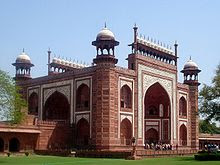
 The Great gate (Darwaza-i rauza)—gateway to the Taj Mahal

In 1631, Shah Jahan, emperor during the Mughal empire's period of greatest prosperity, was grief-stricken when his third wife, Mumtaz Mahal, died during the birth of their 14th child, Gauhara Begum. Construction of the Taj Mahal began in 1632, one year after her death. The court chronicles of Shah Jahan's grief illustrate the love story traditionally held as an inspiration for Taj Mahal. The principal mausoleum was completed in 1648 and the surrounding buildings and garden were finished five years later.

Walkways beside reflecting pool

The Taj Mahal incorporates and expands on design traditions of Persian architecture and earlier Mughal architecture. Specific inspiration came from successful Timurid and Mughal buildings including; the Gur-e Amir (the tomb of Timur, progenitor of the Mughal dynasty, in  Samarkand), Humayun's Tomb, Itmad-Ud-Daulah's Tomb (sometimes called the Baby Taj), and Shah Jahan's own Jama Masjid in Delhi. While earlier Mughal buildings were primarily constructed of red sandstone, Shah Jahan promoted the use of white marble inlaid with semi-precious stones, and buildings under his patronage reached new levels of refinement.        


Friday, February 25, 2011

Middle Ages Wonders

In the 19th and early 20th centuries, some writers claimed that lists of wonders of the world have existed during the Middle Ages, although it is unlikely that these lists originated at that time because the word medieval was not invented until the Enlightenment-era, and the concept of a Middle Age did not become popular until the 16th century. Brewer's refers to them as "later lists" suggesting the lists were created after the Middle Ages.

Many of the structures on these lists were built much earlier than the Medieval Ages, but were well known. These lists go by names such as Wonders of the Middle Ages (implying no specific limitation to seven), Seven Wonders of the Middle Ages, Medieval Mind and Architectural Wonders of the Middle Ages.


1. Colosseum - Italy

 Roman Colosseum

The Colosseum, or the Coliseum, originally the Flavian Amphitheatre (Latin: Amphitheatrum Flavium, Italian Anfiteatro Flavio or Colosseo), is an elliptical amphitheatre in the centre of the city of Rome, Italy, the largest ever built in the Roman Empire. It is considered one of the greatest works of Roman architecture and Roman engineering.

Roman Colosseum

Occupying a site just east of the Roman Forum, its construction started in 72 AD under the emperor Vespasian and was completed in 80 AD under Titus, with further modifications being made during Domitian's reign (81–96). The name "Amphitheatrum Flavium" derives from both Vespasian's and Titus's family name (Flavius, from the gens Flavia).

The exterior of the Colosseum, showing the partially intact outer wall (left
and the mostly intact inner wall (right)

Capable of seating 50,000 spectators, the Colosseum was used for gladiatorial contests and public spectacles such as mock sea battles, animal hunts, executions, re-enactments of famous battles, and dramas based on Classical mythology. The building ceased to be used for entertainment in the early medieval era. It was later reused for such purposes as housing, workshops, quarters for a religious order, a fortress, a quarry, and a Christian shrine.

Original façade of the Colosseum

Although in the 21st century it stays partially ruined because of damage caused by devastating earthquakesiconic symbol of Imperial Rome. It is one of Rome's most popular tourist attractions and still has close connections with the Roman Catholic Church, as each Good Friday the Pope leads a torchlit "Way of the Cross" procession that starts in the area around the Colosseum. 

A panorama of the interior of the Colosseum as it stands now

The Colosseum is also depicted on the Italian version of the five-cent euro coin.


2. Stonehenge - England

The monument from a similar angle in 2008 showing the extent of reconstruction

Stonehenge is a prehistoric monument located in the English county of Wiltshire, about 3.2 kilometres (2.0 mi) west of Amesbury and 13 kilometres (8.1 mi) north of Salisbury. One of the most famous sites in the world, Stonehenge is composed of earthworks surrounding a circular setting of large standing stones. It is at the centre of the most dense complex of Neolithic and Bronze Age monuments in England, including several hundred burial mounds.

Stonehenge at sunset in 2004

Christopher Chippindale's Stonehenge Complete gives the derivation of the name Stonehenge as coming from the Old English words stān meaning "stone", and either hencg meaning "hinge" (because the stone lintels hinge on the upright stones) or hen(c)en meaning "hang" or "gallows" or "instrument of torture". Like Stonehenge's trilithons, medieval gallows consisted of two uprights with a lintel joining them, rather than the inverted L-shape more familiar today. The "henge" portion has given its name to a class of monuments known as henges. Archaeologists define henges as earthworks consisting of a circular banked enclosure with an internal ditch.

Part of Stonehenge

Archaeologists have believed that the iconic stone monument was erected around 2500 BC. One recent theory however, has suggested that the first stones were not erected until 2400-2200 BC, whilst another suggests that bluestones may have been erected at the site as early as 3000 BC. The surrounding circular earth bank and ditch, which constitute the earliest phase of the monument, have been dated to about 3100 BC. The site and its surroundings were added to the UNESCO's list of World Heritage Sites in 1986 in a co-listing with Avebury Henge monument. It is a national legally protected Scheduled Ancient Monument. Stonehenge is owned by the Crown and managed by English Heritage, while the surrounding land is owned by the National Trust.

Fisheye image of Stonehenge showing the circular layout

Archaeological evidence found by the Stonehenge Riverside Project in 2008 indicates that Stonehenge served as a burial ground from its earliest beginnings. The dating of cremated remains found on the site indicate burials from as early as 3000 BC, when the initial ditch and bank were first dug. Burials continued at Stonehenge for at least another 500 years.

Print of Stonehenge, 1895

No one knows exactly what purpose it served, but it is thought to have been a centre of pagan worship. Whatever religious, mystical or spiritual elements were central to Stonehenge, its design includes a celestial observatory function, which might have allowed prediction of eclipse, solstice, equinox and other celestial events important to a contemporary religion.


3. Catacombs of Kom el Shoqafa - Egypt

Catacombs of Kom el Shoqafa

The Catacombs of Kom el Shoqafa, is the Arab translation of the ancient Greek name, Lofus Kiramaikos which means “mound of shards” or “potsherds”. Located to the southwest of the Pompey’s pillar is a multi level labyrinth featuring dozens of chambers adorned with sculpted pillars, statues and other Romano Egyptian religious symbols, burial niches and sarcophagi as well as a banquet room of Roman style, where memorial meals were conducted by relatives of the deceased. 

Catacombs of Kom el Shoqafa

Many of the features of the necropolis merge both Roman, Greek and Egyptian cultural points, due to the time period. So some statues are Egyptian in style, Roman clothes and hair style whilst other features share a similar style. During the age of the Antonine emperors a circular staircase used to transport deceased bodies down the middle of it, leads down into the tombs that were tunneled into the bedrock. So its easy access was then used as a burial chamber. According to tradition, this is a mass burial chamber for the humans and animals massacred by order of the Emperor Caracalla, so this is one of the more gruesome features of the catacombs, called Hall of Caracalla. 

Catacombs of Kom el Shoqafa

Representing an integration of the cultures and traditions of the Egyptians, the cemetery is unique both for their plan and decoration. People seemed to have a talent for combining rather than destroying, so in this place we find decorations related to ancient an Egyptian theme which makes them quite unlike anything in the world. 

Catacombs of Kom el Shoqafa

The Catacombs of Kom el Shoqafa may not be as famous or visible as the Pyramids but they are equally astonishing and perhaps more intriguing than the Pyramids. 

Catacombs of Kom el Shoqafa

In olden days Christians of the Roman Empire this subterranean funeral halls were resorted to bury their dead and evade desecration by the oppressive regimes. Kom el Shoqafa structures were Pagan sects. The members of the Pharoah-Cult placed the intact dead bodies in this place because they believed in rebirths. 

Catacombs of Kom el Shoqafa

Considered by archaeologist and all who love their heritage and history, a real treasure by its scripts written, the motif, the engravings, statues and even the coffins. In a sense catacombs were an escape to the oppressed and the hunted to preserve their rituals and heritage. 


4. Great Wall - China
 
 Great Wall of China

The Great Wall of China is a series of stone and earthen fortifications in northern China, built originally to protect the northern borders of the Chinese Empire against intrusions by various nomadic groups. Several walls have been built since the 5th century BC that are referred to collectively as the Great Wall, which has been rebuilt and maintained from the 5th century BC through the 16th century. One of the most famous is the wall built between 220–206 BC by the first Emperor of China, Qin Shi Huang. Little of that wall remains; the majority of the existing wall was built during the Ming Dynasty.

Great Wall of China

The Great Wall stretches from Shanhaiguan in the east, to Lop Nur in the west, along an arc that roughly delineates the southern edge of Inner Mongolia. The most comprehensive archaeological survey, using advanced technologies, has concluded that the entire Great Wall, with all of its branches, stretches for 8,851.8 km (5,500.3 mi). This is made up of 6,259.6 km (3,889.5 mi) sections of actual wall, 359.7 km (223.5 mi) of trenches and 2,232.5 km (1,387.2 mi) of natural defensive barriers such as hills and rivers.

The Great Wall at Mutianyu, near Beijing

Before the use of bricks, the Great Wall was mainly built from rammed earth, stones, and wood. During the Ming Dynasty, however, bricks were heavily used in many areas of the wall, as were materials such as tiles, lime, and stone. The size and weight of the bricks made them easier to work with than earth and stone, so construction quickened. Additionally, bricks could bear more weight and endure better than rammed earth. Stone can hold under its own weight better than brick, but is more difficult to use. Consequently, stones cut in rectangular shapes were used for the foundation, inner and outer brims, and gateways of the wall. Battlements line the uppermost portion of the vast majority of the wall, with defensive gaps a little over 30 cm (12 in) tall, and about 23 cm (9.1 in) wide.

The Great Wall

While some portions north of Beijing and near tourist centers have been preserved and even extensively renovated, in many locations the Wall is in disrepair. Those parts might serve as a village playground or a source of stones to rebuild houses and roads. Sections of the Wall are also prone to graffiti and vandalism. Parts have been destroyed because the Wall is in the way of construction.


 An area of the sections of the Great Wall at Jinshanling

More than 60 km (37 mi) of the wall in Gansu province may disappear in the next 20 years, due to erosion from sandstorms. In places, the height of the wall has been reduced from more than five meters (16.4 ft) to less than two meters. The square lookout towers that characterize the most famous images of the wall have disappeared completely. Many western sections of the wall are constructed from mud, rather than brick and stone, and thus are more susceptible to erosion.

The Great Wall

Communication between the army units along the length of the Great Wall, including the ability to call reinforcements and warn garrisons of enemy movements, was of high importance. Signal towers were built upon hill tops or other high points along the wall for their visibility.

Photograph of the Great Wall in 1907

The claim the Great Wall is visible has been debunked many times, but is still ingrained in popular culture. The wall is a maximum 9.1 m (30 ft) wide, and is about the same color as the soil surrounding it. Based on the optics of resolving power (distance versus the width of the iris: a few millimeters for the human eye, meters for large telescopes) only an object of reasonable contrast to its surroundings which is 70 mi (110 km) or more in diameter (1 arc-minute) would be visible to the unaided eye from the moon, whose average distance from Earth is 384,393 km (238,851 mi). The apparent width of the Great Wall from the moon is the same as that of a human hair viewed from 2 miles away. To see the wall from the moon would require spatial resolution 17,000 times better than normal (20/20) vision.

The Great Wall

A more controversial question is whether the Wall is visible from low earth orbit (an altitude of as little as 100 miles (160 km)). NASA claims that it is barely visible, and only under nearly perfect conditions; it is no more conspicuous than many other man-made objects. Other authors have argued that due to limitations of the optics of the eye and the spacing of photoreceptors on the retina, it is impossible to see the wall with the naked eye, even from low orbit, and would require visual acuity of 20/3 (7.7 times better than normal).


5. Porcelain Tower of Nanjing - China

The Porcelain Pagoda, as illustrated in 
Fischer von Erlach's Plan of Civil and Historical Architecture (1721)

The Porcelain Tower (or Porcelain Pagoda) of Nanjing, also known as Bao'ensi (meaning "Temple of Gratitude"), is a historical site located on the south bank of the Yangtze in Nanjing, China. It was a pagoda constructed in the 15th century during the Ming Dynasty, but was mostly destroyed in the 19th century during the course of the Taiping Rebellion. The tower is now under reconstruction.

Porcelain Tower of Nanjing

The tower was octagonal with a base of about 97 feet (30 m) in diameter. When it was built, the tower was one of the largest buildings in China, rising up to a height of 260 feet (79 m) with nine stories and a staircase in the middle of the pagoda, which spiraled upwards for 184 steps. The top of the roof was marked by a golden pineapple. There were originally plans to add more stories, according to an American missionary who in 1852 visited Nanjing. There are only a few Chinese pagodas that surpass its height, such as the still existent 275-foot-tall (84 m) 11th-century Liaodi Pagoda in Hebei or the no longer existent 330-foot-tall (100 m) 7th-century wooden pagoda of Chang'an.


The original blocks of the Nanjing Tower's arched door, 
now pieced back together and on display at the Nanjing Museum

The tower was built with white porcelain bricks that were said to reflect the sun's rays during the day, and at night as many as 140 lamps were hung from the building to illuminate the tower. Glazes and stoneware were worked into the porcelain and created a mixture of green, yellow, brown and white designs on the sides of the tower, including animals, flowers and landscapes. The tower was also decorated with numerous Buddhist images.


The original blocks of the Nanjing Tower's arched door, 
now pieced back together and on display at the Nanjing Museum

6. Hagia Sophia - Turkey


View of the Hagia Sophia from Sultanahmet square

Hagia Sophia is a former Orthodox patriarchal basilica, later a mosque, and now a museum in Istanbul, Turkey. From the date of its dedication in 360 until 1453, it served as the cathedral of Constantinople, except between 1204 and 1261, when it was converted to a Roman Catholic cathedral under the Latin Patriarch of Constantinople of the Western Crusader established Latin Empire. The building was a mosque from 29 May 1453 until 1931, when it was secularized. It was opened as a museum on 1 February 1935.

Interior view of the Hagia Sophia, showing Islamic elements in the ceiling.

 Interior view of the Hagia Sophia

The Church was dedicated to the Logos, the second person of the Holy Trinity its dedication feast taking place on December 25, the anniversary of the incarnation of the Logos in Christ. Although it is sometimes referred to as Sancta Sophia (as though it were named after Saint Sophia), sophia is the phonetic spelling in Latin of the Greek word for wisdom - the full name in Greek being Ναός τῆς Ἁγίας τοῦ Θεοῦ Σοφίας, "Church of the Holy Wisdom of God".

Fountain (Şadırvan) for ritual ablutions

Famous in particular for its massive dome, it is considered the epitome of Byzantine architecture and is said to have "changed the history of architecture." It was the largest cathedral in the world for nearly a thousand years, until Seville Cathedral was completed in 1520. The current building was originally constructed as a church between 532 and 537 on the orders of the Byzantine Emperor Justinian and was the third Church of the Holy Wisdom to occupy the site, the previous two having both been destroyed by rioters. It was designed by the Greek scientists Isidore of Miletus, a physicist, and Anthemius of Tralles, a mathematician.

The mihrab located in the apse where the altar used to stand, pointing towards Mecca

The church contained a large collection of holy relics and featured, among other things, a 49 foot (15 m) silver iconostasis. It was the seat of the Patriarch of Constantinople and the religious focal point of the Eastern Orthodox Church for nearly one thousand years. It is the church in which Cardinal Humbert in 1054 excommunicated Michael I Cerularius - which is commonly considered the start of the Great Schism.

Lustration urn from Pergamon

Marble Door

In 1453, Constantinople was conquered by the Ottoman Turks under Sultan Mehmed II, who subsequently ordered the building converted into a mosque. The bells, altar, iconostasis, and sacrificial vessels were removed and many of the mosaics were plastered over. Islamic features — such as the mihrab, minbar, and four minarets — were added while in the possession of the Ottomans. It remained a mosque until 1931 when it was closed to the public for four years. It was re-opened in 1935 as a museum by the Republic of Turkey.

Imperial Gate

Mosaics with geometric pattern decorate the upper imperial gallery

For almost 500 years the principal mosque of Istanbul, Hagia Sophia served as a model for many other Ottoman mosques, such as the Sultan Ahmed Mosque (Blue Mosque of Istanbul), the Şehzade Mosque, the Süleymaniye Mosque, the Rüstem Pasha Mosque and the Kılıç Ali Paşa Mosque.


7. Learning Tower of Pisa - Italy

Leaning Tower of Pisa

The Leaning Tower of Pisa (Italian: Torre pendente di Pisa) or simply the Tower of Pisa (Torre di Pisa) is the campanile, or freestanding bell tower, of the cathedral of the Italian city of Pisa. It is situated behind the Cathedral and is the third oldest structure in Pisa's Cathedral Square (Piazza del Duomo) after the Cathedral and the Baptistry.

View looking up

The height of the tower is 55.86 m (183.27 ft) from the ground on the low side and 56.70 m (186.02 ft) on the high side. The width of the walls at the base is 4.09 m (13.42 ft) and at the top 2.48 m (8.14 ft). Its weight is estimated at 14,500 metric tons (16,000 short tons). The tower has 296 or 294 steps; the seventh floor has two fewer steps on the north-facing staircase. Prior to restoration work performed between 1990 and 2001, the tower leaned at an angle of 5.5 degrees, but the tower now leans at about 3.99 degrees. This means that the top of the tower is displaced horizontally 3.9 metres (12 ft 10 in) from where it would be if the structure were perfectly vertical.

Lead counterweights

Two different masses of cannon balls dropped of the tower to demonstrate that their descending speed was independent of their mass. So it’s considered an apocryphal tale because the only source for it comes from Galileo’s secretary. 

An elevation image of the Leaning Tower of Pisa cut from a 2007 laser scan, 
with source image accurate down to 5mm

A work of art that performed in three stages during 177 years, the construction of the first floor of the white marble campanile began on 1173, and is surrounded by pillars, classical capitals, leaning against blind arches. In 1178 the tower began to sink after construction of the third floor, the cause was a mere three-meter foundation, set in weak, unstable subsoil. Later the construction was subsequently halted for almost a century, the Pisans still engaged in battles with Genoa, Lucca and Florence, which allowed to the underlying soil to settle. In 1198 temporarily clocks was installed on the third floor of the unfinished construction. 

Entrance door to the belltower

In an effort to compensate the tilt, the engineers built higher floors with one side taller than the other, but the tower start to lean in other direction and actually it’s curved. In 1284 the construction was halted again and in 1319 the seventh floor was completed and the bell-chamber was not added until 1372. Tommaso di Andrea Pisano built the bell-chamber with the Romanesque style of the tower. 

Assunta bell

Pasquareccia bell

There are seven bells, one for each note of the musical scale, and the largest one was installed in 1655.
1st bell: L’assuna, weight 3620 kg.
2nd bell: Crocifisso, weight 2462 kg.
3rd bell: San Ranieri, weight 1448 kg.
4th bell: La Terza, weight 300 kg.
5th bell: La Pasquereccia or La Giustizia comes from Easter, because it used to ring on Easter day, weight 1014 kg.
6th bell: It Vespruccio, weight 1000 kg.
7th bell: Dal Pozzo, weight 652 kg. The bell announced capital executions of criminals and traitors, but a new bell was transferred on the bell tower to replace the broken Pasquareccia bell at the end of the 18th century. 

External loggia

Inner staircase from sixth to seventh floor

Benito Mussolini ordered that the tower be returned to a vertical position in 1934, so the concrete was poured into its foundation and the catastrophic result was that the tower actually sank further into the soil.  

View from the top

Inner staircase from seventh to eighth (the top) floor

In 1964, the government of Italy prevents the tower from toppling but was necessary considered to retain the current tilt due to the vital role in the tourism industry of Pisa. On the Azores islands a multinational task force of engineers, mathematicians and historians was assigned to discuss stabilization methods. The reason was the stonework expanding and contracting each day due to the heat of sunlight. Many methods were proposed but only after over two decades of work on the subject, the tower was closed to the public. The solution was to slightly straighten the tower to a safer angle, by removing 38 m3 of soil from underneath the raised end. It was straightened by 45 cm to the position that occupied in 1838, and after a decade of corrective reconstruction and stabilization efforts, the tower was reopened to the public in 2001, and it was declared stable for at least another 300 years.